Newbie question for OnX Maps

PyroTekRob

Member
Nov 3, 2013
120
14
18
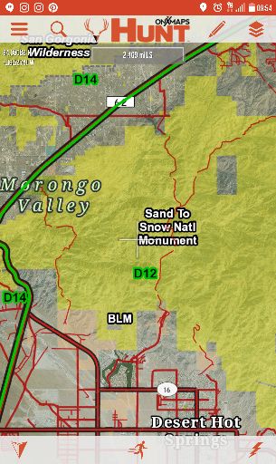
I just started playing with OnX Maps a little last night. Is there a legend available for the color codes? And whats huntable and what is not? When viewing a large area I can see tags like BLM or "X" National forest, but upon zooming closer the tags disappear.

Sent from my LG-H918 using Tapatalk
 
Yellow green light blue should be gtg. Yellow is not, green is nf, lt blue is state. Research it still and know regs. When you click on the area it should tell you square mile area, and what type of land it is, just like how it tells you who owns a he private parcels
 
  • Like
Reactions: PyroTekRob
Thanks and thats what I was pretty sure of. But for example looking at the desert hot springs area there is yellow listed as BLM for the Sand to Snow national monument. There is a desert mountain just north listed in this yellow zone. However a San Bernardino map showing shootin areas show this same area as red. No shoot no hunting..

Sent from my LG-H918 using Tapatalk
 
CLick on the layers and it will show you what each color and sign represents. Great tool I use it all the time and it will probably be one of my most valuable tools if I succeed in AZ this year.
 
Ok but for example when looking at the Big Morongo area Google says no hunting. But under onX its all yellow for BLM and the Sand to Snow Natl monument

7390b6c5d7a26e3e1292ee145c8994ff.jpg


512d57f503d718bf4ad5fee4cc69f191.jpg


And from what I found you can hunt the Sand to Snow area. But theres no separation of the preserve. Unless Its that non colored area with no tag

Sent from my LG-H918 using Tapatalk
 
The Sand to Snow Nalt Monument is broken out. The Big Morongo Canyon Preserve is considered an Area of Critical Environmental Concern (ACEC) and we currently don't display these areas on our map. This one in particular, is within the Sand to Snow Natl Monument.
In general, we provide the public lands, but our customers are still obligated to find any specific regulations for those public lands. Thank you for bringing this to our attention.
You can email us at [email protected] or give us a call with any questions you may have.
Our typical office hours are 8:30 am to 4:30 pm Mountain time, Monday-Friday and we can be reached at 406.540.1600.
 
Last edited:
Just be very careful using Onyx Maps for San Diego. There are several areas that show as CNF that is actually private property.
 
  • Like
Reactions: PyroTekRob
Just be very careful using Onyx Maps for San Diego. There are several areas that show as CNF that is actually private property.
Guess ill get basemaps also as a back up. Might try and swing by my local ranger station and see if they have a map.

Sent from my LG-H918 using Tapatalk
 
Guess ill get basemaps also as a back up. Might try and swing by my local ranger station and see if they have a map.

Sent from my LG-H918 using Tapatalk

Here are a few links that may help you in this situation. The first link you can find a map of the Sand to Snow National Monument. The second is info abut this area.
https://www.blm.gov/documents/california/public-room/map/sand-snow-national-monument
https://www.fs.fed.us/visit/sand-to-snow-national-monument
 
  • Like
Reactions: PyroTekRob

About us

  • SCHoutdoors was created in January of 2011 by a few people who love the outdoors. The main goal is still the same – bring people together who enjoy the outdoors and share their knowledge and experience.
    Outdoors in the West, Hunting gear reviews, Big Game, Small Game, Upland Game, Waterfowl, Varmint, Bow Hunting, long Range Rifles, Reloading, Taxidermy, Salt WaterFishing, Freshwater Fishing, Buy-Sell-Trade on Classifieds and Cooking/Recipes
    All things outdoors…come join us, learn, contribute and become part of the SCHoutdoors community.

Quick Navigation

User Menu