Help Me Out Here, I just want to make sure I'm in the green

Macsteve

Active Member
Jun 23, 2016
300
26
28
Hey guys,
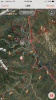
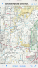
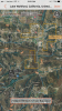
I was trying to do some map scouting and such to find a first location to do coyote/bobcat hunting. to all things I can see, this area seems to be okay to hunt in as long as I'm 150 yards from trails/buildings/dwellings etc. However, I just want to make sure because I don't really have anybody helping me out and the last thing I need is to get in trouble or freak some hippie hikers out and have the rangers after me.

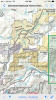
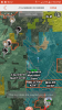
Here are 2 pics I snapped from ONX maps. I know people are sketch about looking at locations and all that, I'm just trying to seek some guidance so I do the right thing. Also its just predator hunting so its not prestigious like some big game stuff.


What are your thoughts?
 

Attachments

  • cuyamaca 1.png
    cuyamaca 1.png
    828.8 KB · Views: 145
  • cuyamaca 2.png
    cuyamaca 2.png
    828.8 KB · Views: 144
Maybe I'm just an idiot then. that red line indicates state park? I was looking at the onx maps legend and trying to figure out where in Descanso district you can actually hunt
 
The solid red line looks like the 79 highway. The thin dotted red lines are trails I think. That whole area is pretty much SP. There is huntable FS land though to the far W and SE of there.

Sent from my SM-N900V using Tapatalk
 
You may want to invest in an actual Cleveland National Forest map. I use one on my android phone through a program called "pdf maps". I believe apple has a version of it as well. The app itself is free.. From there you can purchase maps for individual areas like BLM El Cajon district and Cleveland National Forest
 
dano626 said:
You may want to invest in an actual Cleveland National Forest map. I use one on my android phone through a program called "pdf maps". I believe apple has a version of it as well. The app itself is free.. From there you can purchase maps for individual areas like BLM El Cajon district and Cleveland National Forest

Alright I just bought the cleveland national forest map. I'll try to figure out what I'm looking at and post up again
 
Okay round 2 now that I have that killer map. so all the areas in the yellow are huntable, but not the indian reservation stuff. Is that correct?
 

Attachments

  • cleveland.PNG
    cleveland.PNG
    3.8 MB · Views: 29
  • wohlford.PNG
    wohlford.PNG
    6.3 MB · Views: 25
are you checking the map legend post a pic of that also
 
I may be wrong but you might be on Indian reservation. Correct me if I'm wrong


Sent from my iPhone using Tapatalk
 
Chris_Schulte said:
I may be wrong but you might be on Indian reservation. Correct me if I'm wrong


Sent from my iPhone using Tapatalk

Possibly considering I see Rincon and San pasqual Indian labels.

This one though appears relatively large and no labels at all.
 

Attachments

  • image.png
    image.png
    3.1 MB · Views: 15
#1 there are a lot of big bucks in the SP. If you get caught hunting up there they will hang you out to dry. There is also a lot of indian land in the area you are looking and if you dont have a GPS or know the area you will end up hunting on it. A lot of the time up there you are on cleveland and then indian land on the same road. Be careful and use your GPS.

#2 I know a lot of spots in the area you are posting that are huntable you are on the right track. Get in your truck and drive out there with your Onx maps take an entire Sat you will find spots also try calling the DFG they have loose lips. Maybe even go down to the office with these pictures. I wont tell you where to go but you are on the right track. It is just a matter of knowing how to get to the green areas.
 
Truduct said:
#1 there are a lot of big bucks in the SP. If you get caught hunting up there they will hang you out to dry. There is also a lot of indian land in the area you are looking and if you dont have a GPS or know the area you will end up hunting on it. A lot of the time up there you are on cleveland and then indian land on the same road. Be careful and use your GPS.

#2 I know a lot of spots in the area you are posting that are huntable you are on the right track. Get in your truck and drive out there with your Onx maps take an entire Sat you will find spots also try calling the DFG they have loose lips. Maybe even go down to the office with these pictures. I wont tell you where to go but you are on the right track. It is just a matter of knowing how to get to the green areas.

yeah I definitely screwed up the first time with that State park listing. the other map helps a lot with knowing the area and I guess the ONX map helps with where you are. Although I'm truly having trouble understanding the ONX map because some areas on the ONX map don't reflect the same as the other.

I'm in the early stages, just trying to get my ducks in a row to go out. weekend after this I have my hunter safety so I bet the instructor can give me a few tips as well
 
If you are using the OnX app on your phone make sure you have the CA Gov Lands and CA Private Parcels tabs selected. That way when you are looking at the map you will see the land in color coded sections and also be able to see land boundaries as an orange line. Unfortunately I don't see a color coded map legend that is available to view on the app itself so I went to the OnX website and took a picture of their color coded map legend. Now I just cross reference the picture of the map legend with the color of the land I'm viewing on the app to figure out what is legal and not legal to hunt.
 
Macsteve said:
Truduct said:
#1 there are a lot of big bucks in the SP. If you get caught hunting up there they will hang you out to dry. There is also a lot of indian land in the area you are looking and if you dont have a GPS or know the area you will end up hunting on it. A lot of the time up there you are on cleveland and then indian land on the same road. Be careful and use your GPS.

#2 I know a lot of spots in the area you are posting that are huntable you are on the right track. Get in your truck and drive out there with your Onx maps take an entire Sat you will find spots also try calling the DFG they have loose lips. Maybe even go down to the office with these pictures. I wont tell you where to go but you are on the right track. It is just a matter of knowing how to get to the green areas.

yeah I definitely screwed up the first time with that State park listing. the other map helps a lot with knowing the area and I guess the ONX map helps with where you are. Although I'm truly having trouble understanding the ONX map because some areas on the ONX map don't reflect the same as the other.

I'm in the early stages, just trying to get my ducks in a row to go out. weekend after this I have my hunter safety so I bet the instructor can give me a few tips as well
a812f89766151387ed5703f67bf79497.jpg


Yea man u gotta turn on your map overlays so u can see the boundaries for NF, SP, Rez, etc. Then like Josh said cross reference other maps and Google earth, etc to figure out what's good.
 
Macsteve said:
Okay round 2 now that I have that killer map. so all the areas in the yellow are huntable, but not the indian reservation stuff. Is that correct?

you definately have the wrong map or your layers are set to full transparency, this is what it should look like,and that spot is indian reservation
 

Attachments

  • Screenshot_20160629-201457.png
    Screenshot_20160629-201457.png
    3.7 MB · Views: 19
Since you mention you are a newbie, you now know the joy of hunting. You always have to figure out where trouble is and avoid it. Hunting parks or the Res are no-nos.

Good luck.
 

About us

  • SCHoutdoors was created in January of 2011 by a few people who love the outdoors. The main goal is still the same – bring people together who enjoy the outdoors and share their knowledge and experience.
    Outdoors in the West, Hunting gear reviews, Big Game, Small Game, Upland Game, Waterfowl, Varmint, Bow Hunting, long Range Rifles, Reloading, Taxidermy, Salt WaterFishing, Freshwater Fishing, Buy-Sell-Trade on Classifieds and Cooking/Recipes
    All things outdoors…come join us, learn, contribute and become part of the SCHoutdoors community.

Quick Navigation

User Menu