ONX is an awesome tool, but you would be foolish to just rely on one source. I always check my spots against the county assesor data. That is where ONX gets their information. You have to remember ONX does this all across the nation. Some of the data they pull in is from small counties and some counties they cant even get data for. I bet some of the larger counties have some sort of data feed that they send ONX with some sort of regularity, but I think ONX updates once a year or so.What's the sense of having Onx if it's not up to date monthly? Those preserves didn't just show up overnight.
")
Do you have to buy OnX for each state, or do you buy it once and it works in all states ??
So is it's public land but a city owns it (ex. City of San Diego etc) I can't hunt there?
Onx is by far the best tool for hunting available. Found a D16spot I thought would hold deer last week on ONX hikes in yesterday with my kid and we were seeing deer and deer sign all morning not to mention a flowing natural spring. ONX is completely up to date I have not experienced any problems with boundaries, preserves etc. I have spots from the border all the way to temecula because of ONX. If you do see a problem email ONX and they will fix it. I sent them an access discrepancy from AZ last year and they fixed it.
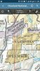
The issue with reserves in San Diego is more than likely that City of SD land is light yellow and BLM is dark yellow.
I truly believe with ONX and some of the other online tools available that if you can’t find deer you are not trying. I have at least 100 pins from D16 on my ONX screen it is an incredible tool. With that said nothing beats boots on the ground and eyes behind glass. Waste some gas and you will find more spots than you can hunt.
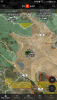
thanks for the info. I need to double check some of my waypoints. I had that one marked "scout". hahaI agree, ONX is an awesome tool, its helped me find no less than 5 new spots this year alone I wouldnt have thought about. I will continue to purchase it every year as it a tremendous help in locating new spots, but you still have to make sure it is correct. I just wanted to relay my experience in double checking the ONX info because of the preserve issues I found. Here are screenshots of one the areas. ONX clearly shows Capitan Open Space Preserve as BLM. My CNF map thru Avenza maps app and my paper maps show it is clearly Capitan Preserve. I will say that I havent found any issues so far with lands labeled as CNF .