Mt Laguna. Hunting

Juan

Active Member
Jul 10, 2017
116
83
28
41
Just wondering where I can get info on where the boundary line starts in mount Laguna to hunt with rifle, or is it just archery.
 
Last edited:
You will need a map for sure, preferably one with grid lines etc. so you can better tell where you are. And within the boundaries, it is archery only.
 
Last edited by a moderator:
  • Like
Reactions: Juan
The CNF hard copy maps show the boundary.. I personally like the spiral bound, quadrangle topo map ($20). Attached is a Google image, not sure how accurate it is.
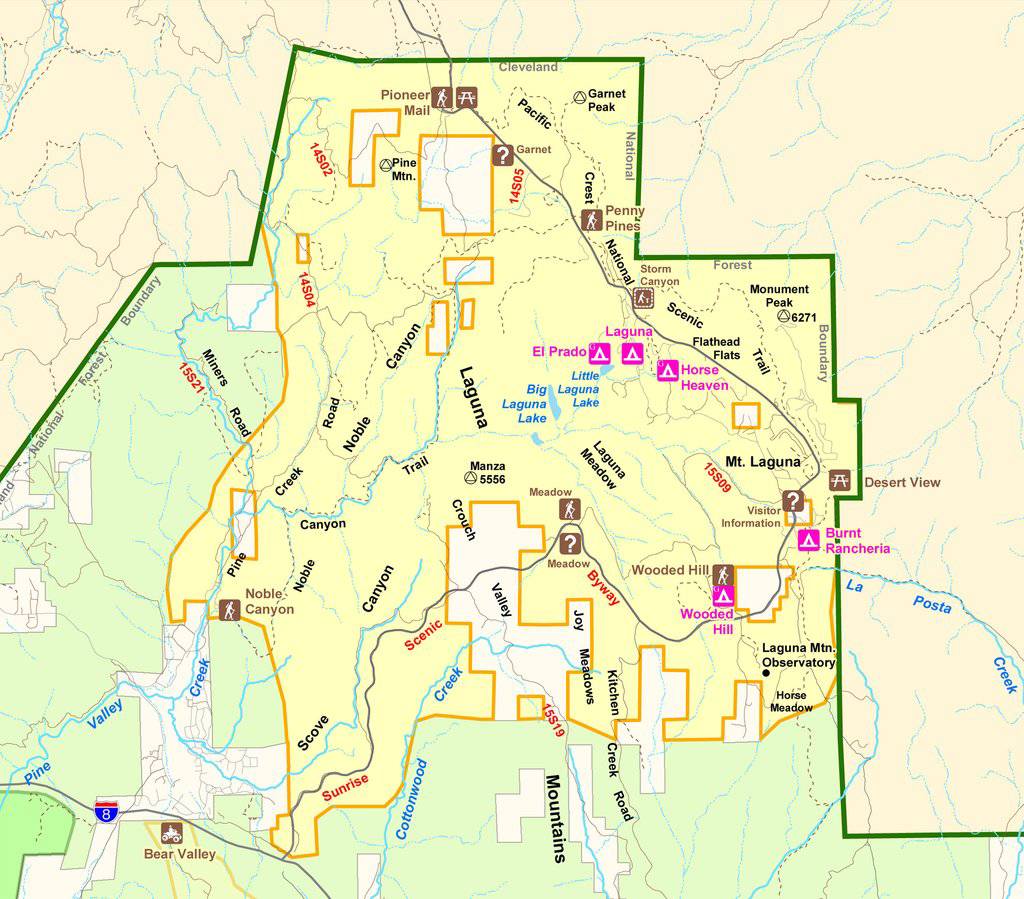
d79406ad5db6268600ca988a5480061f.jpg


Sent from my SM-G965U using Tapatalk
 
  • Like
Reactions: Goyaałé
The CNF hard copy maps show the boundary.. I personally like the spiral bound, quadrangle topo map ($20). Attached is a Google image, not sure how accurate it is.
d79406ad5db6268600ca988a5480061f.jpg


Sent from my SM-G965U using Tapatalk

Correct me if I am wrong, the yellow is where you can archery hunt?


Sent from my iPhone using Tapatalk
 
That map does not show the Laguna boundaries. The green bold line is the CNF boundary. While the Laguna Rec area is in the yellow it does not show the boundary. The visitors station near the Laguna Store has the area maps. The big folded version of the CNF map will show the red dotted boundary around the rec area.
 
  • Like
Reactions: Juan
That map does not show the Laguna boundaries. The green bold line is the CNF boundary. While the Laguna Rec area is in the yellow it does not show the boundary. The visitors station near the Laguna Store has the area maps. The big folded version of the CNF map will show the red dotted boundary around the rec area.

Awesome Thanks l, for the info!


Sent from my iPhone using Tapatalk
 
The CNF hard copy maps show the boundary.. I personally like the spiral bound, quadrangle topo map ($20). Attached is a Google image, not sure how accurate it is.

Sent from my SM-G965U using Tapatalk

This is a very good map to pass around and tell people they can't use rifles in the yellow ;), maybe it would clear out a large area for the rest of us with the CNF maps.
 
  • Like
Reactions: socalhntr and Juan
Honestly, I dont even really look at my paper maps anymore. I do carry them in my pack in case of battery issues. I use a few apps to figure out public land.
ONXhunt
Avenza maps ( has a downloadable version of the folded CNF map, along with others...BLM and such.)
Google earth
 
  • Like
Reactions: Juan and Bowman
This has been by far the worst year I have seen in forty plus years when it comes to rifle hunters hunting in the recreational area of the Lagunas which is only for archery. This has been so frustrating this year with my cameras being shut off and stolen by rifle hunters, but they don’t see the other cameras I have which took pictures of all of them and I have turned all these pictures into the DFG, so they can see how bad this is becoming. The bottom line is if you can even see pine trees you are in the wrong area. I know there has been changes over the years, but it used to be that you could not be above 4500 feet with a rifle in that area. I am a rifle hunter also, so I have respect for everyone’s efforts, but this is getting out of control in the Lagunas and I know one person gets shot from a stray bullet and they will close this rec area for all of us, there just looking for a reason to take this area away from us.
 

About us

  • SCHoutdoors was created in January of 2011 by a few people who love the outdoors. The main goal is still the same – bring people together who enjoy the outdoors and share their knowledge and experience.
    Outdoors in the West, Hunting gear reviews, Big Game, Small Game, Upland Game, Waterfowl, Varmint, Bow Hunting, long Range Rifles, Reloading, Taxidermy, Salt WaterFishing, Freshwater Fishing, Buy-Sell-Trade on Classifieds and Cooking/Recipes
    All things outdoors…come join us, learn, contribute and become part of the SCHoutdoors community.

Quick Navigation

User Menu